Wednesday, June 16, 2010

Scotts Bluff, Nebraska

Note: Several of the pictures below have annotations - you can click on any picture to enlarge it if you need to see it better.

On Monday, June 14th, my long awaited medicine finally came and we left Ogallala after a week’s stay. Took Hwys 92 & 26 west through Lewellen, Oshkosh, Lisco, Broadwater, and Minatare to Scottsbluff. The town of Gering adjoins Scottsbluff to the south and we got a nice campsite at a Gering city RV park. Our campsite looks out over an open expanse of land at the Scotts Bluff National Monument - a huge free-standing rock formation. This was one of the landmarks for the travelers on the Oregon Trail.


Tuesday was a sightseeing day. After the Oregon Trail emigrants had endured endless miles of mostly rolling plains, prairies, and sand hills, they started seeing huge rock formations that were landmarks they had been looking for. Three of the most famous are Courthouse Rock, Jail Rock, and Chimney Rock. Courthouse Rock and Jail Rock are side by side and kind of square and blocky looking. They are out in the middle of the countryside - no visitor’s center or anything.

Here are a couple of pictures of the two rock formations from two different perspectives.


The more famous rock formation is Chimney Rock. The sighting of it signaled to the Oregon Trail pioneers that they were about a third of the way on their journey and also told them that they were about to enter a more mountainous and difficult terrain. It is now a National Historical Site with a nice new Visitor‘s Center. Chimney Rock is a lone rock formation that looks like an inverted funnel - a half mile around at the base and the spire that juts up 325 feet.

Here are two pictures of Chimney Rock from two different perspectives.


South of Scottsbluff is the Wildcat Hills Range - a solid line of rock and pine covered hills probably 700-800 feet high that run east and west for many miles. At the top on Hwy 71 is the Wildcat Hills Recreation Area and Nature Center. The views from the Nature Center looking out over the flat lands toward Scottsbluff are awesome.


Wednesday (today) was another sightseeing trip, but a short one. The Scotts Bluff National Monument is only a little over a mile away. We have a great view of it from our campsite Of course, from our campsite vantage point we have only one aspect of it - the look of it changes tremendously from different perspectives.

In addition to the one from our campsite, here’s a couple more pictures of Scotts Bluff.


Mitchell Pass is where all the wagons went through. Again, you can still see the high banks on either side of where the wagon road got wore down into the earth. There is a paved road through the pass now just to the south of the wagon road, but in the days of the Oregon Trail emigrants, it was narrow and they had to go through single file. Amazing what bulldozers and earth movers can do.


Just outside the Visitor Center there is a section of the old wagon path that you can walk. Along this path, they have three replica wagons set up with interpreters dressed in 1850’s period costumes to explain things and answer any questions you might have.


We drove the park road all the way to the top of Scotts Bluff. It is the largest of the rock formations and from the top you have a fantastic view in all directions Very close on the south is Mitchell Pass and on the opposite side of the pass there are several other huge rock formations - Dome Rock, Crown Rock, and Sentinel Rock. The tallest and most vertical part of Scotts Bluff is the north side of the pass and is named Eagle Rock.

Here’s three pictures from the top of Scotts Bluff.


We’re now through with the Nebraska portion of the Oregon Trail and like the travelers back in the mid 1800’s, we’re moving on to Wyoming tomorrow!

Sunday, June 13, 2010

Ogallala, Nebraska #2

Our plan was to leave Ogallala on Thursday, June 10th, but some medicine I had ordered and had shipped to Ogallala hadn’t come it by Wednesday. It also didn’t come in Thursday or Friday, so Friday we moved to another state park campground. This one is on Lake Ogallala which is (strange as it sounds) down below the dam of Lake McConaughy.


The pipe at the spillway of the dam that they use to let water out of Lake McConaughy is at least 6-8 feet in diameter and the water spouting out of it is an awesome sight.


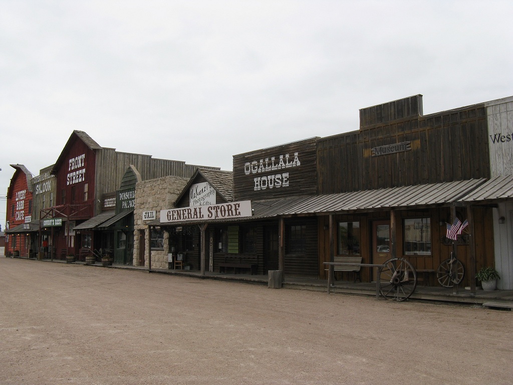
It was a wet, cloudy, stormy, dreary weekend. We spent Saturday afternoon checking out the museum and shops at “Front Street” - a replica of Ogallala back in the 1800’s. Ogallala was the destination of a lot of the cattle drives from Texas and was a rough and rowdy place. The museum had lots of old time cowboy stuff.


Sunday - rain, rain, rain early, then cloudy and cool the rest of the day. We attended a very good worship service at the First Baptist Church of Ogallala and then spent a relaxing afternoon watching the Braves game. Hopefully, we’ll be able to hit the trail tomorrow!

Wednesday, June 9, 2010

Ogallala, Nebraska #1

On Monday June 7th we left Kearney, NE and hit I-80 west for about 150 miles to Ogallala, NE - made famous in the TV mini-series Lonesome Dove. Along the way we crossed from Central Time into Mountain Time. About 14 miles north of town is Lake McConaughy (pronounced Mc-Con-a-hay) and we got a nice campsite on the lake at Lone Eagle campground - another Nebraska State Recreation Area.


On Tuesday we did the Oregon Trail touristy places - California Hill, Windlass Hill, and Ash Hollow. We went to California Hill first - this is one of the few places where you can still see the ruts made by the wagon wheels. You have to drive a small dirt road for about a half mile, park, and then walk several hundred yards out across a pasture. As you climb the “hill”, you can really see where the wagons went - it’s like a road that got wore down into the earth with banks on each side. Also, you actually can see the ruts of the wagon wheels in a few places. Here’s a couple of pictures.


After California Hill we headed to Windlass Hill and Ash Hollow. The settlers, after climbing California Hill headed northwest across the rolling sand hills until they came to Windlass Hill. It is a very, very steep descent and they had to lock the wagon wheels, hold back on the wagons with ropes, and hope for the best. A legend says they used a windlass to let the wagons down the hill, but there is no historical evidence supporting this. Still though - that’s how the hill got its name. Where the wagons came down is now a ravine - washed deep over the 150+ years. The park service has a concrete path for visitors to walk if they want to go to the top of the hill - we did. From the top - WOW, what a view!


It's awesome to stand there and realize that the settlers came to that same spot, looked down that hill, and said, “We gotta go down that??” - not to mention what the oxen and mules must have thought.


After getting down Windlass Hill, the settlers then found themselves in a beautiful valley along the North Platte River populated with a lot of Ash trees - hence the name Ash Hollow. Here they rested up several days before proceeding on northwest following the river. Today the Nebraska park service has a nice Visitor Center (closed Monday-Wednesday due to budget cuts), a couple of trails, and a nice picnic area.

Wednesday we drove about 30 miles west to Oshkosh, then another 25 miles north to the Crescent Lake National Wildlife Refuge. The last 25 miles was a dirt road across endless ‘high plains’ - rolling grasslands, no trees, forever & ever. It took awhile to get to the NWR and then we drove their auto tour loop (6-8 miles) around the lake which was a narrow little track through the grasslands - just two sandy ruts for the tires with high grass on both sides and in the middle. Signs said 4-wheel drive recommended.


On the 25 mile road in & out of the NWR we drove slow did see a few new birds to add to out list - a Lark Bunting, a Blue Grosbeak, a Northern Shoveler, a Northern Harrier, a Grasshopper Sparrow, and a Horned Lark. Here is a picture of a Horned Lark.


We also went through some open range country and had a big herd of cows and new calves close to the road checking us out.

Sunday, June 6, 2010

Ft. Kearny, Nebraska #3

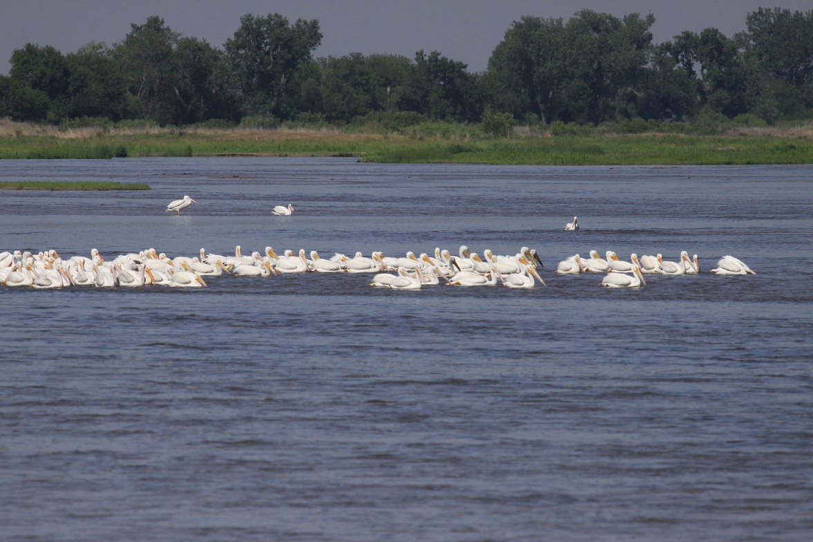
On Saturday we went to the Rowe Sanctuary and Iain Nicholson Audubon Center, but they were closed (only open during the week). The place is located right along the bank of the Platte River and there were a couple of trails that we walked for a little while. Saw a few birds to add to our list - White Pelicans and a Belted Kingfisher.


On the way back, we saw one of our favorite birds of the mid-west - a Bobolink.


Later we visited the Ft. Kearny State Historical Site - the actual location where the original fort was situated. You can still see some of the foundations of the other buildings and they have a replica of the stockade and a re-created sod constructed blacksmith shop. There are several old wagons scattered around the grounds. They had a sign at the entrance that showed the trails that came through here.


We found out an interesting item - the town and the fort are spelled differently. The town is Kearney, but everything associated with the fort is Kearny. The man for whom the fort was named was Kearny (no 2nd ‘e’). The girl at the Visitor’s Center didn’t know how the town wound up with an extra ‘e’.

Attended a very good worship service at the First Baptist Church in Kearney on Sunday - very friendly crowd, all ages, great music and sermon. Spent a relaxed Sunday afternoon with a rain shower, a pizza and the Braves game. It’s been a very enjoyable stay here, but tomorrow it’s time to move on up the trail.

Friday, June 4, 2010

Ft. Kearny, Nebraska #2

On Friday we went to “Pioneer Village” - one of the area’s largest attractions located about 10 miles south in the small town of Minden. This place has been here for years and its main theme is the progress of the settlers in this area from the early 1800’s up to present day - I guess you could classify it as a museum.


There are 26 separate buildings that house everything you can imagine - huge farm equipment, over 300 antique automobiles, tractors, home furnishings, musical instruments, china and glassware, clothing, and on, and on, and on. The advertisements say there are over 50,000 items, but we know that there were more than that in one of the buildings. Among the buildings is a church, a general store, a school house, a livery stable, a blacksmith shop, a train station, a sod house, and a Pony Express station. There were also buildings that housed all the antique autos, antique tractors, china & glassware, early appliances, furniture, and hobbies (collectibles). Here’s a few pictures of some of the buildings.


We spent about 5 hours walking around looking at all the stuff and didn’t really “see” it all. We did spend time looking at the things that interested us the most, but a lot of it was mostly a stroll through. It would take several days to really look at all it in any detail.

We took over 100 pictures - here are just a few more.


Thursday, June 3, 2010

Ft. Kearny, Nebraska #1

On Wednesday, June 2nd, we left Lewis & Clark State Park and headed out on the Oregon Trail. We by-passed Lawrence and Topeka, KS (we had heard there was some Indian trouble in that area) and crossed the Missouri River in Atchison, KS and traveled across the northeast corner of Kansas and then up into southern Nebraska. Out of Fairbury, NE we headed north and hit I-80 west at York, NE. We made it through Grand Island to Kearney and got a nice campsite at the Ft. Kearny State Recreation Area.

There is a lot of history in this area. Ft. Kearny was built in 1848 to protect travelers on the Oregon Trail and it was the first of 6 major forts the pioneers would pass on their way west. It also served as a Pony Express and Overland Stage station. War Department records show that 30,000 passed through the fort during one 18-month period in the late 1840’s. A decade later, the march was still on - one report indicated that 800 wagons rolled through on a single day just before the Civil War.

On Thursday we checked out The Great Platte River Road Archway Monument which is a huge attraction where the whole building arches across I-80 just before the Kearney exit. The major theme is westward migration over the years and how it has evolved to present day.


On the lower level is the gift shop, restaurant, and restroom facilities. After the ticket purchase in the gift shop, you go up a very long escalator to the 2nd level and then follow through all the various still and animated displays - beginning with the settlers who migrated west on the Oregon, California, and Mormon Trails, followed by the Pony Express, the Overland Stage, the Trans-Continental Railroad, the Lincoln Highway (the first for automobiles), and finally the interstate. They gave you a set of earphones at the beginning and there was a running commentary all along that changed as you proceeded through the various segments.


At the end there were two windows where you could look out at the traffic going both directions on I-80. We spent about 2 hours there and thought it was money well spent - we enjoyed it.

We are here for several days, so I will be making one or two more posts from here later.