Friday morning we left Bay City, Michigan. We checked the mileage to home and realized that rather than try to find a state park or some other campground with vacancies on a holiday weekend, we could just make the drive all the way home in two days. So - we hit I-75 south for 428 miles on Friday and stopped for the night at a Wal-Mart parking lot in Georgetown, Kentucky. Then yesterday we made the last 320 miles and arrived at home about 4:30.
What a great trip this has been. The history of the Oregon Trail and the learning experience we had traveling it was fantastic. Also, Hwy 2 across the northern tier of the USA on the return trip was an experience in itself. Totally on this trip we drove 7503 miles and covered 16 states. We were short 1 week being gone for a total of 4 months. The USA does have some beautiful, scenic country and we were blessed to see a lot of it. Also, we were well blessed and can’t thank God enough for the safe, trouble-free travel. God is definitely GOOD!
For all of you that followed along with us on this blog - we were very glad to have you along and hope you enjoyed it. Until next time ----- D&L
Sunday, September 5, 2010
Thursday, September 2, 2010
St. Ignace, Michigan - Upper Peninsula
On Monday, August 30, we left the North Shore of Lake Superior in Minnesota, Hwy 61 south to Duluth, across into Wisconsin on I-535, then US Hwy 2 east across the northern part of Wisconsin. This is supposed to be the Dairy Capital of America, but that must be in the southern portion. We didn’t see even one cheese shop, and only saw two cows. The landscape was mostly timberland - a mix of hardwood, pine, and cedar.
It was only 100 or so miles across Wisconsin, and we crossed into the Upper Peninsula of Michigan. The terrain is still mostly woodlands. About halfway across the UP we stopped at the Bewabic State Park near Crystal Falls for the night.

On Tuesday, August 31, we continued 228 miles on US Hwy 2 east to St. Ignace and got a campsite at Straits State Park. This campground is right on the Straits of Mackinac which separate the Upper and Lower Peninsulas of Michigan from north to south and Lake Michigan and Lake Huron from west to east.
Yesterday (Wednesday) we did a little sightseeing in the area. One of the big draws in this area is Mackinac Island which is 3 miles off shore in Lake Huron. The only way to get there is by private boat, ferry, small plane, or snowmobile in winter. The island only has a year-round population of 523, but as many as 15,000 visitors per day flock to the island during the tourist season. There are no motor vehicles allowed (except the snowmobiles in winter) and once there, the only way to get around is by foot, bicycle, or horse drawn carriage. The attraction is all the hotels, restaurants, bars, and retail shops that line the streets. We opted not to make the trip over to the island - too much time, effort, and cost involved just to walk up and down the streets awhile looking and shopping.


One of the sights in St. Ignace is the Mackinac Bridge. “Big Mac“ or “Mighty Mac“, as it is called, is the 3rd longest suspension bridge in the world and the longest between anchorages in the Western Hemisphere. It was put into service in 1957 and crosses the Straits of Mackinac. The bridge is 5 miles long It carries 4 lanes of I-75 across the straits from the Upper to the Lower Peninsula of Michigan - we crossed it today.


As we were riding around yesterday in St. Ignace we happened to see this beautiful relic! What a car!!!

Today we left St. Ignace and the Upper Peninsula and made it 182 miles south on I-75. We got a campsite at Bay City State Park in Bay City, MI on Saginaw Bay.
Sunday, August 29, 2010
North Shore of Lake Superior - Minnesota
On Thursday, August 26, we left Lake Bemidji State Park and drove a little over 225 miles to Silver bay on Minnesota’s North Shore of Lake Superior. We followed US Hwy 2 to Duluth. We think we were traveling through the southern portion of Minnesota’s Great North Woods, and there were a couple of National Forests that we passed through, but the rest of the terrain was young growth forest - mostly pines, with a few hardwoods along. Very few farms. Timber is a big industry in these parts, thus the adolescent woodlands.
In Duluth we took Hwy 53, then Hwy 61 north to the North Shore of Lake Superior and got a campsite in a State Forest campground.
Lake Superior is the largest of the Great lakes - but how much larger than the others is probably not well known. Lake Superior is 350 miles long, 160 miles wide, and with a shore line of 2725 miles, is 31,820 square miles - roughly the size of South Carolina. The average depth is 482 feet with a maximum depth of 1132 feet. The average temp in summer is 40 degrees - pretty chilly. From the information we read, it could contain the volume of all the other Great Lakes plus 3 additional Lake Eries.
Friday was a day of sightseeing on the North Shore. We stopped at Tettegouche State Park where the Baptism River enters Lake Superior. We walked a trail to the mouth of the river. At the mouth of the river is a huge “gravel bar” (like a sand bar, but covered with rocks).


We were really surprised at the shore line in all of this area. I guess we were expecting a gradual sloping terrain with maybe sandy shores, but the shore is very rugged with high cliffs at the waters edge. Not much sunbathing going on around here. However, it is very beautiful and scenic.


We also visited Split Rock Lighthouse State Park. From the picnic area of the park we found a trail that allowed us to get out far enough on the rocks to get a really good view of the lighthouse.

In the community of Beaver Bay LaVerne spied a flea market that had the whole front yard full of tables filled with all kinds of glassware. She had to stop and check it all out. They did have a lot of really beautiful stuff, but their prices were very high.

Saturday we moved about 40 miles south back down Hwy 61 to the town of Two Harbors. Got a nice campsite in a municipal park campground. This afternoon after church we did some riding on the North Shore in the Two Harbors area. The town gets it name from the two harbors divided by a rocky point - Burlington Bay where our campground is and Agate Bay. From the picture below you can see that the shore is still real rocky, but it is not the high cliffs like it is farther north. The Two Harbors Lighthouse is the oldest working lighthouse in Minnesota and has guarded the point between the two harbors since 1892.


The US Coastguard has built a nice concrete jetty out into Agate Bay with a light at the end. It was nice for a Sunday afternoon stroll.

Tomorrow we’re leaving the North Shore and moving on east across northern Wisconsin headed to the Upper Peninsula of Michigan.
Wednesday, August 25, 2010
Lake Bemidji State Park - Bemidji, Minnesota
Monday we left Grahams Island State Park at Devil’s Lake, ND and traveled a little over 225 miles east on US Hwy 2 to Lake Bemidji State Park near Bemidji, Minnesota. We left the Great Plains and got into mostly rolling timbered terrain, Still lots of farms, but now the crops are more of corn and soybeans. The mix of pine and hardwood forests looks a lot like home.
Yesterday, Tuesday, we went about 50 miles southwest to Lake Itasca State park and the Headwaters of the Mississippi River. There has been controversy over the actual beginning point of the river, but the general consensus is that the Mississippi begins as a small stream flowing out of Lake Itasca. The park service has placed rocks across the outlet of the lake and you can walk across the Mississippi over the rocks (and get your feet wet), or 50 feet or so downstream you can cross on a foot log. Needless to say, this was a very interesting place - especially considering what the Mississippi River looks like downstream at places like St. Louis, Vicksburg, and New Orleans.


Today we stayed at camp and took a nice walk to Big Bog Lake here in the park. The hike was a little over a mile (one way) through a mostly Black Spruce and Tamarac forest with the last quarter mile being over a long boardwalk through the marshy bog to the lake.

All along the boardwalk visitors can observe all kinds of vegetation - Pitcher Plants, insect eating Sundews, Orchids, Rush-Asters, and many other plants. This time of year there were no Orchids in bloom.


Tomorrow we will be headed on to the North Shore area Minnesota on Lake Superior
Sunday, August 22, 2010
Grahams Island State Park - Devil's Lake, ND
Thursday we left Minot ND and traveled a little over 100 miles east on Hwy 2 to Devil’s Lake and Grahams Island State Park. We are now in what’s called the “Prairie Pothole” region of the Great Plains. It’s an area that contains thousands of shallow wetlands known as “potholes”. These “potholes” are depressions left by glacial activity many years ago. They have filled with water and provide important temporary habitat for over 50% of North America’s migratory waterfowl. This “Prairie Pothole” Region stretches from Alberta, Saskatchewan, and Manitoba in Canada down through North and South Dakota and into Iowa of the USA.


Devil’s Lake is HUGE and the road to Grahams Island State Park crosses a 3-mile causeway across the lake. Reminds me of the old “causeway” in Mobile, AL.

This is a really nice state park - lots of open grassy areas and shade trees spaced enough to still preserve the feel of openness. Again, you can compare the pictures below to the previous one of our last campsite and see why we prefer state parks.


We’ve been here since Thursday and have had the opportunity to do some riding & checking out the waterfowl around the lake and at the “potholes” in the area. We saw this flock of American Avocets - always thought they were quite interesting.


Tomorrow we’re on the move again - Minnesota here we come.
Wednesday, August 18, 2010
Minot, North Dakota
Yesterday, Tuesday, we left Lewis & Clark State Park near Williston, ND and traveled a little over 100 miles east on Hwy 2 to Minot. No state parks close to here, so we had to get a commercial RV park. The campsites are really different than the state parks - usually jammed up pretty close to your neighbor. Compare this picture to the one in the previous post and you’ll see why we prefer state parks when we can get them.

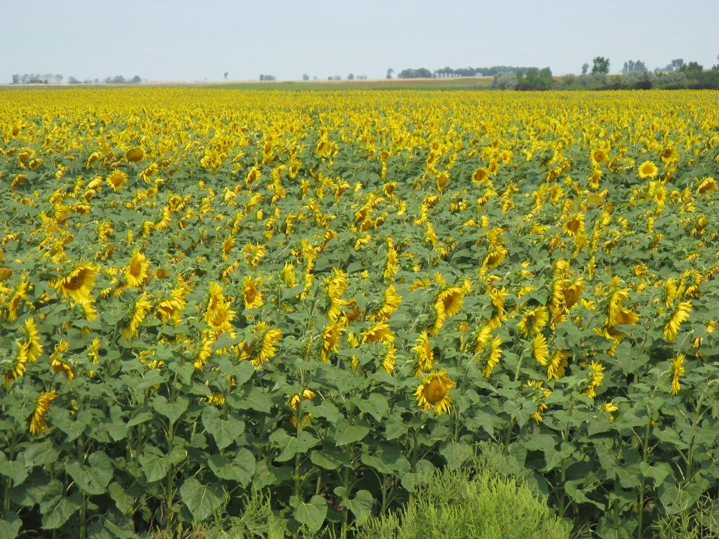
On the drive here yesterday and also in the riding we did today, we’re seeing lots of Sunflower fields. They are beautiful, and it’s amazing how the heads of the plants follow the sun throughout the day.


Today we went to Upper Souris National Wildlife Refuge about 30 miles north of Minot. We went to the Visitor Center, then drove the scenic auto-tour through the refuge. There were thousands of American Coots, and lots of ducks of various species. We haven’t been seeing many ducks until today and we think the fall migration is starting.


At one spot, a Barn Swallow was sitting on a sign posing for us.

Tomorrow is another travel day - still farther east on US Hwy 2.

On the drive here yesterday and also in the riding we did today, we’re seeing lots of Sunflower fields. They are beautiful, and it’s amazing how the heads of the plants follow the sun throughout the day.

Today we went to Upper Souris National Wildlife Refuge about 30 miles north of Minot. We went to the Visitor Center, then drove the scenic auto-tour through the refuge. There were thousands of American Coots, and lots of ducks of various species. We haven’t been seeing many ducks until today and we think the fall migration is starting.


At one spot, a Barn Swallow was sitting on a sign posing for us.

Tomorrow is another travel day - still farther east on US Hwy 2.
Monday, August 16, 2010
Williston, North Dakota
Sunday afternoon after church in Williston we moved from a pretty junky RV park to Lewis & Clark State Park about 20 miles east of town. We had stayed here twice before, back in 2006 and again in 2008. We got a really nice campsite with a big front yard.

Today, Monday, we went to the Missouri-Yellowstone Confluence Interpretive Center. As the name implies, this is where the Yellowstone River comes in and joins the Missouri River. The area has lots of history - especially pertaining to the Lewis & Clark Expedition back in 1805 & 1806. We had visited this place back in 2006 when we followed the L&C Trail and had enjoyed it. Today was a good re-visit.


The grounds are home to small prairie dogs and one sat outside his house and posed for us.

This post is a little short, but we weren’t here long and tomorrow we’re moving on a little farther east in North Dakota.
Saturday, August 14, 2010
US Highway 2 Across Montana
Yesterday, Friday the 13th, we left Glacier National Park and headed east on US Hwy 2. At Browning, Montana the landscape changed completely from mountains to high plains. For 2 days we traveled across Montana - 540 miles. We stopped Friday and spent the night in the Wal-Mart parking lot in Havre, Montana, then continued today on to Williston, North Dakota. Today we also crossed from Mountain Time back into Central Time. Montana is not called the Big Sky Country for nothing!

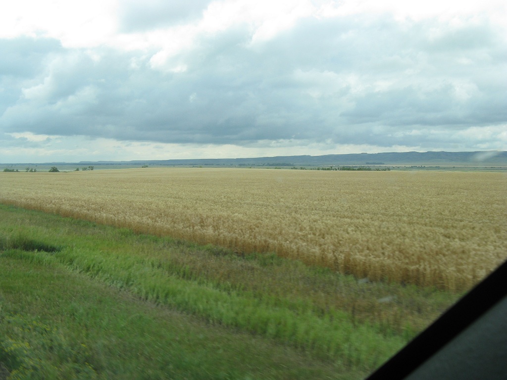
Although we did see some regular hay and corn fields, the big crop across Montana is wheat. Miles and miles past huge wheat fields.


Hwy 2 is 2-lane across Montana and over each hill it seems like you can see forever.


It was surprising - there were a few cattle farms, but not as many as expected. We did see lots of horses.

As we got into eastern Montana, we left the big wheat farms and other cultivated crops and started seeing a lot more rolling hills. This type of landscape continues into North Dakota.


We plan on being in the Williston area a couple of days, then it will be farther east on Hwy 2.
Subscribe to:
Posts (Atom)
